
A great and short article about stregthening and underpinning (reprise en sous oeuvre)
Strengthening and underpinning the foundations of the main building
of the Ministry of Foreign Affairs of Finland
Renforcement et reprise des efforts en sous-oeuvre des fondations de l`édifice du Ministère des Affaires Étrangères de Finlande

Renforcement et reprise des efforts en sous-oeuvre des fondations de l`édifice du Ministère des Affaires Étrangères de Finlande
!! CLICK HERE !!
This is why...
This is you should really start to think about geotechnical investigations

Weathering of granitic rocks
Spheroidal, onion skins weathering and granular desintegration ("grusification").
Silicate rocks are not completely soluble in water, they are subject to differential weathering...Spheroidal weathering :
Let's take a look of this kind of weathering

Karlu Karlu Reserve, Northen Territory, Australia. source
We can often observe this kind of structures when some weathered areas have been cleared by road works.
Hydration is the main chemical process breaking granite down, rain water is acid (contains disolved CO2, humic acides...) and affects the rock.
Let see what happens more specifically with these cartoons :

Resistant vs easily weathered beds
I have take some pictures and make a cartoon that show the resistant vs easily weathered beds:


Soil forming processes
Today we will talk about a bit of rock weathering and soil forming processes.
We can start by saying that weathering processes are most severe, active in tropical climes but almost hidden by the cover of vegetation as you can see in the picture below.

In this kind of place we are going to get more redox reactions than in a temperate climate.
This example was given to underlie the fact that what we can learn about weathering in a part of world can be completly different in an other part !
We call "Pedology" the study of soils ;
Soils are divisible into layers called horizons. There is thousand and thousands of different soils across the world... Weather conditions and geomorphic settings affect the thickness and the composition of these soils.

 Note how C horizons are variable... very difficult to analysis from boreholes
Soil formation is dominated by a physical processes are analogous to the percolation of coffee :

We can start by saying that weathering processes are most severe, active in tropical climes but almost hidden by the cover of vegetation as you can see in the picture below.
In this kind of place we are going to get more redox reactions than in a temperate climate.
This example was given to underlie the fact that what we can learn about weathering in a part of world can be completly different in an other part !
We call "Pedology" the study of soils ;
Soils are divisible into layers called horizons. There is thousand and thousands of different soils across the world... Weather conditions and geomorphic settings affect the thickness and the composition of these soils.
Soil formation is dominated by a physical processes are analogous to the percolation of coffee :
The basaltic column --- Les orgues basaltiques
You can find some explanations here : english website
ou ici en français : site français
Scheibenberg, (the Krušné Mountains, Germany) :


Région d'Auvergne, France :

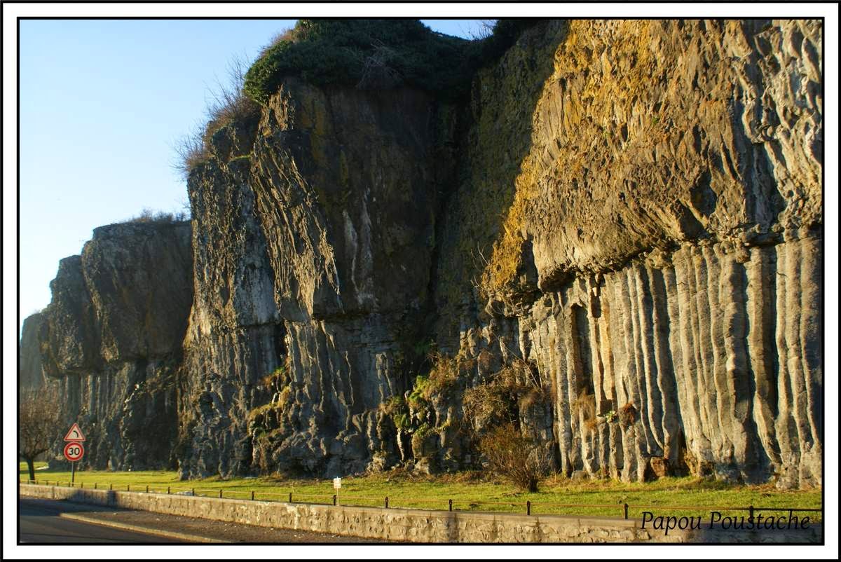


Iceland : one of the most beautiful examples :


[to be continued]
ou ici en français : site français
Scheibenberg, (the Krušné Mountains, Germany) :
Iceland : one of the most beautiful examples :
[to be continued]
Yeager Airport Mudslide in Charleston, West Virginia, Stalls After Damaging Multiple Homes
A mudslide near Yeager Airport in Charleston, West Virginia, seems to have settled after damaging several homes and destroying a home and church.
The slide decimated Keystone Apostolic church and caused flooding, damaging several homes in the process, WSAZ-TV said.
Residents who voluntarily evacuated 130 homes may have to remain in hotels for a bit longer, as airport officials cannot give an estimate on a return date, WSAZ reported.
"Yeager Airport is a fairly unique airport in that it was built on top of a hill due to the lack of suitable flat land for a commercial airport. To make the hilltop flat enough for runways, 9 million cubic yards of earth and rock were moved when the airport was built in the 1940s. It's not surprising, then, that there might be some areas vulnerable to landslides after a spell of warm, wet weather following a prolonged deep freeze," said weather.com senior meteorologist Nick Wiltgen.
Yeager Airport public information officer Mike Plante told WSAZ, "At this point, I wouldn't want to speculate with too much specificity because we just don't know. A lot depends on the weather. A lot depends on what the engineers tell us; what they can do and when they can do it."
Officials are worried rain could worsen the landslide.
"On top of this wet soil and everything else, it's a big concern for us," Kanawha County's emergency services deputy director C.W. Sigman said.
Wiltgen said the airport has seen about 4.14 inches of rainfall since March 1, more than twice the amount it normally sees the first 12 days of the month.

Photo Credit: Jerry Waters photo/For the Charleston Gazette

Photo Credit: Jerry Waters photo/For the Charleston Gazette
The Kanawha County Emergency Services deputy director told The Weather Channel officials are not asking residents to leave due to concerns of the slide falling on homes, but because of the risk of flooding after the landslide created a dam on the Elks Two Mile creek. At 10:30 a.m. Friday morning, excavation crews were working to clear the creek of mud and rock to avoid additional flooding, WSAZ said.
The Air National Guard 130th Airlift Wing Fire Department and Pinch Volunteer Fire Department crews worked torescue a man who was stranded after the footbridge leading to his home was washed away Thursday, C.W. Sigman, deputy director of Kanawha County emergency services, told The Charleston Gazette.
(FORECAST: First Day of Spring to Disappoint)
Five residents were stranded in their homes after additional slides, and crews from local fire departments came to their aid with boats, preparing to evacuate them by Two Mile creek if necessary, WSAZ reported. All five were safely rescued.
The Associated Press reported the landslide broke a gas line, cutting off the supply to about 30 customers.
Yeager Airport officials stationed an observer in the parking lot of Keystone Apostolic Church, who allegedly spotted the new slide activity, The Charleston Gazette noted.
Kanawha County School buses stopped service to Keystone Road due to the danger the mudslide presented and will be running on a new schedule, WOWK-TV said.
Kent Carper, Kanawha County Commission, told WOWK, "Public Safety is our first and last priority. I urge everyone in the area to take this advisory seriously and err on the side of caution. Yeager Airport will help arrange accommodations for anyonewho needs them." The airport has not ceased any activity due to the slide.
Sigman expects families will not be able to return to their homes for a few days, the Associated Press reported.
By Carolyn Willi, weather.com
Tackling Grand Challenges in Geochemistry: Q&A with Andrew Stack
Newswise — Andrew Stack, a geochemist at the Department of Energy’s Oak Ridge National Laboratory, advances understanding of the dynamics of minerals underground. He earned his doctorate in geology from the University of Wyoming in 2002 and went on to become a postgraduate researcher at the University of California–Davis and assistant professor at the Georgia Institute of Technology before joining ORNL in 2010 to investigate chemical reactions of minerals in soils and rocks. He is a member of the American Chemical Society and the Geochemical Society. Stack and his team make discoveries that will help to improve our understanding of a wide range of energy-related issues, such as geologic storage of carbon dioxide, oil and gas discovery and development, and remediation of toxic contaminants. Following is Part II of a Q&A with Stack [Part I is posted here] detailing his current research, which spans three disciplines—geology, chemistry and computing.
Q: What is geochemistry and why is it critical to the Department of Energy?
A: Geochemistry is literally the chemistry of the Earth, but there are a couple of different types. One type uses the chemical composition of minerals to help interpret geology or past climate. The kind of work that I do is different—I want to understand the reaction mechanisms that occur on minerals from a fundamental perspective. Understanding those reaction mechanisms turns out to be very useful for predicting groundwater composition, trapping of contaminants underground or predicting the suitability of a waste repository, which are important to DOE.
Q: What big scientific questions interest you?
A: I’ll quote a friend, George Redden at Idaho National Laboratory, who said that when dealing with reactions underground, you’ve got control over only three things: what you inject, how fast you inject it, and where you inject it. And that’s all you can really control. Coupled with limited ability to control things at the beginning is that predicting what is going to happen in geological systems in general is a really large-scale problem, especially when it’s something like certifying a nuclear waste repository to store waste safely for a million years. In addition to the large time and length scales of natural processes, there are variations in the minerals, their reactivity and the distributions of pores in rocks that control fluid flow, which may mean that what you study in the laboratory is difficult to extrapolate to the real world. Given all that, my feeling is that a better understanding of geochemistry, while not a complete answer, is going to be useful any time things happen, or you want things to happen or not happen, under the ground, whether during hydraulic fracturing or re-injecting the waste fluid from that process, geologic carbon storage (a.k.a. carbon sequestration) or nuclear waste disposal.
Q: Does fundamental research create understanding that would help develop a better ability to predict geochemical reactions?
A: Absolutely! Right now a lot of computational models are being run to understand transport of fluids like water and hydrocarbons through rock and their interactions with the surrounding rock. These models don’t include very realistic geochemical reactions, though. The geochemistry has been simplified to make the problem easier to simulate, but it is really over-simplified. It’s becoming increasingly clear that the ability to model subsurface processes is essential to obtaining an accurate predictive capability for contaminant transport. Making these kinds of predictions is a daunting task because of the wide range of time and length scales involved.
Q: If that task is daunting, what will success look like?
A: If I could look back on my career and declare success, it would be because some expressions for mineral growth and dissolution that I developed were used inside a large-scale model to predict contaminant transport over time, for example at a spent nuclear fuel storage facility or a carbon sequestration site. Even better than just predicting contaminant transport would be using these kinds of models to show that a toxic contaminant can and will be immobilized.
Q: You won a recent award for a talk about atomic- to pore-scale probes and predictions of mineral reactivity. What approach does that research take?
A: In our core geosciences project funded by the US Department of Energy’s Office of Basic Energy Sciences, our group is interested in understanding mineral reactions going from atoms to pores, particularly mineral precipitation and dissolution. Say you want to find out if a mineral is going to form in a groundwater. You pull up some well water, analyze its composition and see how it compares with the stability of various minerals. The problem with that approach is that you have a very difficult time accounting for all the important factors that affect the mineral reactions and why. A mineral grain’s roughness, morphology, how many defects and impurities it has—all play a role in how it reacts. These issues are important, not only to see if contaminants might be sequestered, but also because mineral precipitation and dissolution can block or enhance fluid flow in porous geologic formations, which is the primary control on contaminant transport.
The approach that our group takes in our core project is to try to understand growth or dissolution from the mineral’s perspective. We study things like the specific chemical reactions it undergoes and how those atomic-scale processes affect the overall water composition and the porosity of the rock. There are a bunch of different types of atomic sites on a mineral’s surface, and each has potentially different chemical reactivity. All of these sites act in concert to create the net reactivity of the mineral, and that in turn determines the water composition. Predicting if a mineral will precipitate is more difficult in rocks. Because rocks are porous, water (or other fluids) moves through them slowly, and so the transport of reactants and products in the water to the mineral becomes important in controlling its growth. That presents some additional challenges, to try and understand what mineral reactions will take place, and how they occur. But the basic question we’re trying to answer is: when you have a given solution composition moving through a rock, what minerals will precipitate or dissolve and how fast will it happen?
Q: Can you tell me a bit about your latest research?
A: When I was a postdoc I had discovered that crystal shape depended on the atomic-level reaction mechanisms controlling the mineral’s growth, but I didn’t know what those were precisely. In a recent paper in the Journal of the American Chemical Society, I and two researchers from Curtin University in Australia— Julian Gale and Paolo Raiteri—finally got it right. We found a mechanism for barite growth and dissolution with a variation in rate as a function of temperature that matched the experimental measurements. To discover this, we simulated the attachment and detachment process of a barium ion onto an atomic-level feature of a barite surface called a “step.” These steps are important because their advance or retreat is the mechanism by which the mineral grows or dissolves and takes its shape. Each one is made of one or two molecular rows of the mineral, and a crystal grows because ions are constantly incorporated at the step edges. We simulated the mechanism of how the barium ions attach to or detach from the steps and the amount of energy it takes to do that. Finally, we related those parameters to the experimental measurements and found they matched.
Q: Why is barite important?
A: It’s mostly known geochemically because it has a low solubility that causes it to clog pores in rocks, wells, pipes and equipment. We’re interested in avoiding precipitation where it blocks permeability, but taking advantage of that property and using it in other subsurface environments to trap radium. Radium is a problem for some proposed spent nuclear fuel storage sites because it doesn’t adsorb well onto a lot of minerals, especially the clay minerals normally used to stop contaminants from spreading. But if you can trap the radium as an impurity in barium sulfate, it won’t be going anywhere. Another issue is that—during hydraulic fracturing—wells have salty water that comes up along with the natural gas or oil. A few wells have dissolved barium, radium and strontium coming up to the surface too. In fact, radium is the dominant component in terms of the total radioactivity of these brines. These are so-called RCRA compounds, for the Resource Conservation and Recovery Act of 1976. You are not allowed to dump these metals in streams because they’re toxic and/or radioactive. Since you don’t want the radium coming up to the surface, our group is working on the idea of trapping the radium and barium by controlling the precipitation of barium sulfate. That is the topic of our Laboratory Directed Research and Development (LDRD) project. LDRD awards support cutting-edge research and enhance the lab’s ability to obtain external funding to address DOE missions.
Q: Is geochemistry important for carbon capture and storage?
A: That’s what we’re trying to find out. For carbon sequestration, you want to pump carbon dioxide into the ground and you want it to stay there. The safest way to ensure that is to know if the carbon dioxide will dissolve in the surrounding groundwater and react to form a carbonate mineral like calcite, which is calcium carbonate. The idea is that if you can trap the contaminant as a solid mineral, it’s not going anywhere for a long time. That is where geochemistry comes in. Our job is to find out how much carbonate mineral will form, how long it will take and how it affects the communication of fluids in the rock.
Q: How are government researchers focusing their efforts in geologic carbon storage?
A: We explore aspects of this problem in an Energy Frontier Research Center (EFRC) called the Center for Nanoscale Control of Geologic CO2. It’s run out of Lawrence Berkeley National Laboratory, but Oak Ridge National Laboratory is the largest partnering institution. This EFRC was initially funded for 5 years, and was renewed in June 2014 and awarded $12.8 million over an additional 4 years to characterize and understand nanoscale to pore-scale processes that control the trapping of carbon dioxide in subsurface rock formations.

Q: Recently you wrote a paper in the journal Environmental Science & Technology with implications for carbon storage. What did you discover?
A: Our finding adds a new wrinkle to the question: what is the size of the pores in which minerals prefer to form? The answer will have implications for carbon storage, because if you want to convert the carbon dioxide to a mineral, you would like to make efficient use of all the pores. What I and other researchers from the Center for Nanoscale Control of Geologic CO2 showed in this paper is that you can get precipitation in the smallest pores, but only if there’s a favorable chemical interaction between the mineral and the host rock. Otherwise, you only see minerals forming in the larger pores, where they might block large-scale fluid flow.
Q: What are the next grand challenges in geochemistry and what’s your vision for addressing them?
A: Earlier I mentioned this atom-to-pores concept— translating atomic-level reactions on a mineral into how these reactions occur in the pores that control fluid flow in geologic formations. Our group has made enough progress that, while we haven’t got the puzzle finished yet, we have just enough pieces to see what the finished picture might look like. For the next 5 or 10 years, we’re going to try to finish that puzzle. If it works, it will be incredibly useful; but it will require cooperation among scientists working at different scales and areas of expertise. Geochemistry can be useful for addressing a lot of different grand challenges for society, which all fall under the general heading of “how do we maintain or even enhance our standard of living without degrading the environment and endangering ourselves in the process?”
Q: Can you tell me about some of the techniques you use to push the frontiers of geochemistry?
A: Working at a DOE lab gives me access to advanced national research facilities that maintain capabilities that individual universities or companies do not operate. Some are the Spallation Neutron Source (SNS) and the High Flux Isotope Reactor (HFIR), DOE User Facilities at ORNL. SNS is an accelerator-based neutron source that provides the most intense neutron beams in the world for scientific research and industrial development, and HFIR is a powerful reactor-based source. We use these in a couple of ways. One way (at HFIR) relies on the fact that neutrons have no net electric charge so they pass through relatively thick sections of rock. By measuring how much the neutrons scatter at smaller angles we can get information about the distribution of pores in a rock (how big they are) and how that changes as minerals dissolve and precipitate. Another way that we use neutrons at SNS is to examine the atomic structure of ions dissolved in solution, or the dynamics of water adsorbed to minerals. These studies help us in building the puzzle pieces I just mentioned.
Q: What geochemistry challenges keep you up at night?
A: I’m constantly asking myself what is the most interesting science that I could do that is also useful for society. If you want to know what I worry about most though, it’s not the science. I worry about society continuing to take advantage of the benefits of funding basic research. I think part of the problem is that we as scientists have to do a better job of explaining to people how the things that we’re doing and learning are helpful to them. Mineral precipitation in rocks is not exactly dinner table conversation, because it’s outside of most people’s everyday experience. But this and other such geochemical processes largely determine things like the discovery and extraction of oil and gas, the safe disposal of energy-related contaminants and even the huge amounts of clean fresh water from underground aquifers that we rely so heavily on. I don’t think we scientists do a good enough job of explaining to non-scientists why we should study something. It’s also not enough to obtain funding and do good science—for that science to be really useful there has to be a way for society to take advantage of it too. That becomes especially difficult when the science contradicts someone’s interests or deeply held beliefs. What is the best way for scientists to deal with that?—interview by Dawn Levy
IMAGE 1, Stack_2015-P00294
CAPTION/CREDIT
Oak Ridge National Laboratory geochemist Andrew Stack and his team make discoveries that will help to improve geologic storage of carbon dioxide and remediation of toxic contaminants. Image credit: Oak Ridge National Laboratory, U.S. Dept. of Energy; photographer Carlos Jones
CAPTION/CREDIT
Oak Ridge National Laboratory geochemist Andrew Stack and his team make discoveries that will help to improve geologic storage of carbon dioxide and remediation of toxic contaminants. Image credit: Oak Ridge National Laboratory, U.S. Dept. of Energy; photographer Carlos Jones
Subglacior, une sonde dans les archives du climat
Subglacior, une sonde dans les archives du climat
Le Monde.fr | | Par Vahé Ter Minassian
Quelle sera l’importance du réchauffement climatique au cours des prochaines décennies ? Une partie de la réponse à cette question se trouve peut-être cachée en Antarctique depuis plus d’un million d’années. Les spécialistes estiment en effet que la calotte polaire dissimulerait quelque part, à plusieurs milliers de mètres au-dessous de sa surface, des glaces très anciennes datant du milieu de l’ère du pléistocène. De précieux échantillons qui non seulement seraient porteurs d’informations sur l’histoire reculée du continent blanc, mais pourraient aussi servir à établir certains mécanismes mal connus du climat actuel.

« Doigt thermique »
En savoir plus sur http://www.lemonde.fr/sciences/article/2015/04/06/subglacior-une-sonde-dans-les-archives-du-climat_4610440_1650684.html#AHauI3WWeHGqxPFb.99
Encore faudrait-il pour cela réussir à les repérer et les récupérer. Ce qui va prendre du temps. Tant les zones où ils subsistent encore sont rares, et tant sont grandes et nombreuses les difficultés techniques à surmonter.
Le 26 mars, la fondation BNP Paribas présentait, en tant que mécène, la description d’une invention qui pourrait considérablement accélérer les opérations de recouvrement de ces archives climatiques. Imaginée par des équipes issues de quatre laboratoires français, la sonde Subglacior, qui sera testée à la fin de l’année 2016 sur la base franco-italienne Concordia (Antarctique), a été conçue pour évaluer rapidement l’âge des glaces qu’un site renferme. Deux mois suffiront pour mener à bien cette tâche, contre quatre ou cinq ans en moyenne aujourd’hui !
Considérée comme un objectif prioritaire par la communauté des spécialistes, la mise au jour de la glace la plus vieille du monde mobilise les équipes concurrentes de plusieurs nations. Chinois, Japonais, Américains et Européens concentrent leurs recherches sur quatre « dômes » du plateau antarctique. A la clé : un gain en termes de prestige bien sûr, mais surtout la perspective de réelles avancées scientifiques. « L’analyse des glaces donne accès à la température et à la concentration de l’atmosphère dans le passé, explique Jérôme Chappellaz, directeur de recherche CNRS au Laboratoire de glaciologie et géophysique de l’environnement, à Grenoble, un des instigateurs du projet Subglacior. Plus elles sont anciennes, plus il est possible de remonter loin dans le temps. Des échantillons datant de 800 000 à 1,5 million d’années livreraient ainsi des informations sur un épisode du milieu du pléistocène, au cours duquel le rythme des variations climatiques s’est profondément modifié, passant d’un cycle de 40 000 ans à un autre de 100 000 ans. L’étude de cet événement très particulier pourrait nous permettre d’établir certains caractères du climat actuel. Par exemple, sa sensibilité aux changements de la quantité de gaz à effet de serre contenus dans l’atmosphère. »
Problème : aucun des moyens existants ne permet de prédire à coup sûr l’emplacement de telles glaces. Si des méthodes permettent de repérer des zones plus favorables que d’autres, les équipes n’ont aujourd’hui au bout du compte d’autres choix que de procéder à un carottage « à l’aveugle » de la calotte polaire, afin de s’assurer de leur présence à plusieurs milliers de mètres de profondeur. Une technique onéreuse, lente et risquée, sans garantie de succès. Pour peu qu’à l’endroit du forage les glaces du soubassement (et donc les plus anciennes) aient été mélangées ou aient fondu au fil des millénaires, toute l’opération se soldera par un échec !
D’où l’idée d’un instrument maniable à même de procéder à une sorte de reconnaissance subglaciaire préalable au carottage. Telle est la fonction du Subglacior. Cette sonde de 15 mètres de long et de 12 centimètres de diamètre, reliée à la surface par un câble flexible, creusera la glace en l’évacuant dans un fluide de forage sous forme de copeaux. Elle sera équipée à sa tête, au niveau de sa foreuse, d’un « doigt thermique » à même de fondre des échantillons tout au long de sa progression. Amenés dans la chambre interne d’un spectromètre laser mis au point au Laboratoire interdisciplinaire de physique de Grenoble, ces fluides seront analysés en continu afin d’établir leur teneur en deutérium (un isotope de l’hydrogène) et en méthane. Des informations qui permettront aux scientifiques de dater la glace durant la descente et ainsi d’établir, durant une seule campagne australe de deux mois, si le site choisi est pertinent.
Testée dans de l’eau à l’été 2014 en Méditerranée, cette sonde instrumentée, unique au monde, et dont le développement en cours implique aussi l’Institut national des sciences de l’Univers du CNRS et le Laboratoire des sciences du climat et de l’environnement à Saclay (Essonne), sera expérimentée, dans un premier temps, à Concordia. Les chercheurs souhaitent y vérifier son bon fonctionnement en comparant ses résultats à ceux déjà obtenus sur place par le forage Epica. En 2004, ce programme européen avait permis de récupérer plus de 800 000 ans d’archives climatiques sous forme de carottes, soit la plus longue séquence arrachée à ce jour à l’Antarctique.
Si ces essais se révèlent concluants, Subglacior sera alors transporté, en 2017, à une cinquantaine de kilomètres de là, sur un site candidat « à la plus vieille glace ». Repéré durant l’hiver 2011-2012 au cours d’un raid de l’Institut polaire français consistant en un aller-retour de 1 200 km entre les bases franco-italiennes de Concordia et la base russe de Vostok, une « zone d’écoulement » située à la verticale d’une « montagne » y focalise actuellement l’attention. Ce secteur d’une cinquantaine de kilomètres de côté, caractérisé par une faible épaisseur de glace de 2 600 à 2 700 mètres et des précipitations annuelles réduites, sera ainsi survolé à la fin 2015 par un avion américain doté d’un radar. Le but : identifier le meilleur endroit où installer un forage.


Planetary Scientists Shed NEw Light on Earth's Core Formation
Planetary Scientists Shed New Light on Earth’s Core Formation
Violent collisions between the infant Earth and other objects in our Solar System generated significant amounts of iron vapor, says a group of researchers led by Dr Richard Kraus of Harvard University and the Lawrence Livermore National Laboratory.

Earth. Image credit: Kelvin Song / CC BY-SA 3.0.
Dr Kraus and his colleagues used one of the world’s most powerful radiation sources, the Sandia National Laboratories Z-machine, to recreate conditions that led to the formation of our planet.
They developed a new technique to determine the critical impact conditions needed to vaporize the iron.
They subjected iron samples to high shock pressures in the machine, slamming aluminum plates into iron samples at extremely high speeds.
The results, published in the journal Nature Geoscience, show that iron vaporizes easily during impact events, which forces planetary scientists to change how they think about the growth of planets and evolution of our Solar System.
Dr Kraus said: “the results may shift how planetary scientists think about the processes and timing of Earth’s core formation.”
For scientists, one of the most important and complex research areas is predicting how planets form and evolve to their current state.
Generally speaking, planets form by a series of impacts, with the speed of the impacts being slow at first, a few km per hour, but then faster as the planets grow larger, up to 160,000 km per hour.
At the end stages of formation, when the impact speeds are high and the material conditions are extreme, scientists don’t have great models for how to describe what happens to the colliding bodies.
“One major problem is how we model iron during impact events, as it is a major component of planets and its behavior is critical to how we understand planet formation,” Dr Kraus said.
“In particular, it is the fraction of that iron that is vaporized on impact that is not well understood.”
He added: “rather than the iron in the colliding objects sinking down directly to the Earth’s growing core, the iron is vaporized and spread over the surface within a vapor plume. This means that the iron can mix much more easily with Earth’s mantle.”
“The timing of Earth’s core formation can only be determined via chemical signatures in Earth’s mantle, a technique that requires assumptions about how well the iron is mixed,” he noted.
“This new information actually changes our estimates for the timing of when Earth’s core was formed.”
The findings may also explain why the Moon lacks iron-rich material despite being exposed to similarly violent collisions.
The scientists suggest the Moon’s reduced gravity could have prevented it from retaining most of the vaporized iron.
_____
Richard G. Kraus et al. Impact vaporization of planetesimal cores in the late stages of planet formation. Nature Geoscience, published online March 02, 2015; doi: 10.1038/ngeo2369
Inscription à :
Articles
(
Atom
)


